
Apps
Travel & Local
S-Vigia
S-Vigia

| Package ID: | |
|---|---|
| Latest Version: | v1.0.8 |
| Latest update: | May 25, 2026 13:19:05 |
| Developer: | Destino Chicamocha |
| Requirements: | Android |
| Category: | Travel & Local |
| Size: | 83.75 MB |
| Tags: | Navigation Photo Date |
Rating :4.2
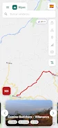
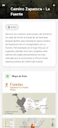
S-Vigia helps hikers and trekkers explore Santander's most spectacular routes with navigation and safety tools designed for the terrain. The app combines connectivity heat maps (RSRP) to show where mobile signal is strong or likely to drop, high-precision GPS routes delivered as GeoJSON files that follow municipal boundaries and authorized trails, an integrated alert and SOS panic button that sends your exact location to local authorities and support groups, plus community reviews and a tourist directory with local services and hydration points—ideal for trips around Zapatoca, Guane, Barichara and the Chicamocha Canyon.
Key Features
⭐ S-Vigia connectivity maps (RSRP) display signal heat maps so you can plan calls and reports before entering low-coverage areas.
⭐ Specialized GPS navigation using high-precision GeoJSON routes that guide you along municipal boundaries and authorized trails.
⭐ Integrated alert and SOS panic button to send your precise location to local authorities and support groups in emergencies.
⭐ Community experiences and reviews where hikers share photos, current trail conditions and notable points of interest.
⭐ Tourist directory listing nearby guides, local services and hydration stations around popular Santander routes.
Advantages
✅ S-Vigia improves route safety by revealing coverage gaps and providing a direct emergency alert option.
✅ Detailed GeoJSON routes reduce navigation uncertainty and help keep hikers on authorized municipal paths.
✅ Community reviews deliver first-hand updates about trail conditions and highlight recommended viewpoints.
✅ The tourist directory makes it easier to find guides, services and hydration points close to your itinerary.
Disadvantages
❎ Coverage and official route data are focused on Santander (Zapatoca, Guane, Barichara and surrounding areas), so the app has limited use outside this region.
❎ Trail condition reports rely on community contributions and may not always reflect the very latest changes on a route.