
Apps
Travel & Local
Nature Path Guide
Nature Path Guide

| Package ID: | |
|---|---|
| Latest Version: | v1.0.0 |
| Latest update: | May 27, 2026 17:14:03 |
| Developer: | ChurChat |
| Requirements: | Android |
| Category: | Travel & Local |
| Size: | 30.00 MB |
| Tags: | Common System Navigation |
Rating :4.1
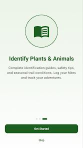
Nature Path Guide is a practical offline navigation and field guide app built for hikers, backpackers and people who spend time in nature. Nature Path Guide helps you find trails, identify common plants and animals, and record trips even when phone signal is unreliable; it stores trail routes and elevation profiles inside the app so you can plan and navigate off-grid. The design favors clear maps, straightforward controls and concise reference content so you can spend less time fiddling with settings and more time on the trail.
Key Features
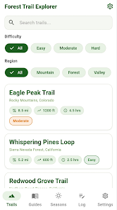
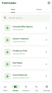
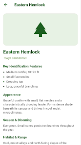
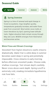
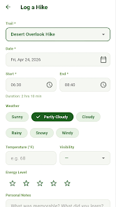
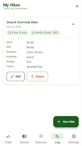
Nature Path Guide includes embedded routes with elevation profiles so maps and waypoints remain available without cellular data, a searchable encyclopedia of common wildlife and plants with identifying characteristics and habitat notes, and a compact hike log for weather, duration and observations. You can filter routes by difficulty or region and read seasonal safety advice that highlights what to pack and what conditions to expect. The app intentionally focuses on essential tools for safer and more informed outings rather than complex subscription features.
Navigation and Controls
The navigation approach centers on simple tap-and-swipe controls for map interaction and route selection. Pan and zoom gestures control the map, a single tap opens route details and elevation profiles, and straightforward buttons let you start or stop a trip log. Turn-by-turn guidance is not required for the app to be useful; instead it provides clear route overlays, distance markers and elevation graphs that keep orientation obvious even when you must rely on your own map-reading skills. Controls are designed to be responsive whether you use the app for a short day hike or a multi-hour walk.
Progression and Personal Tracking
Rather than gamified rankings, progression in Nature Path Guide is personal and practical: the app helps you choose routes that match your current ability and then record hikes to track improvement over time. The hike log records distance, elevation gain, estimated difficulty and field notes so you can compare past outings and plan slightly harder or longer routes as your confidence grows. This system supports gradual progression for users who want to increase endurance or attempt more technical trails without imposing competitive elements.
Map Style, Visual Design and Level Structure
Maps use clear, high-contrast styling with color-coded trail difficulty indicators and labeled elevation profiles that make terrain features and ascents easy to interpret at a glance. Trails are organized into regions and difficulty tiers so you can browse nearby loops, out-and-back options or longer multi-segment routes. The visual presentation emphasizes legibility on small screens: trail lines, contour shading and waypoint icons remain distinct at common zoom levels so you can understand route structure quickly when preparing or while en route.
Customization and User Experience
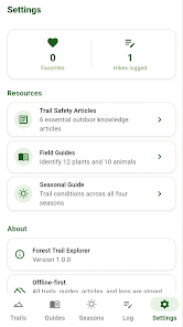
Nature Path Guide provides practical customization like metric or imperial units, map orientation preferences and offline route downloads. Users can save favorite routes, add brief personal notes to their hike logs and choose how much map detail is visible in offline mode to balance storage and coverage. The general user experience favors quick access to essential information: route length, elevation gain, estimated duration and seasonal tips are displayed together so decisions about what to bring and which route to pick are straightforward.
Replay Value and Challenge Systems
The app encourages replay by making it easy to revisit and compare routes and by storing a history of observations that become useful references for future trips. Challenge is provided by route selection and environmental conditions rather than artificial rewards: you decide to attempt a longer distance, a higher elevation gain or a route in a different season, and the app supplies the practical data you need to do so safely and responsibly.
Accessibility and Offline Reliability
Accessibility options include adjustable text size, clear iconography and high-contrast map themes that help readability in bright outdoor light. Offline functionality is central: all critical map data, route overlays and the encyclopedia entries required for identification are available without cell service, and the app is built to minimize battery drain by limiting background processes while tracking a hike. This makes Nature Path Guide a reliable companion for remote outings where connectivity cannot be relied upon.
Coverage and Limitations
The app emphasizes common species and well-documented trails; the built-in encyclopedia focuses on frequently encountered plants and animals and may not identify rare or poorly documented organisms. Trail and map coverage is limited to the database of routes included with the app, and trip logs depend on user-entered notes for qualitative observations rather than automated third-party weather or sensor data. These trade-offs keep the app lightweight and focused on practical field use.
For hikers who want clear offline maps, simple controls and a concise field guide, Nature Path Guide offers a no-frills toolkit that supports safer, better-informed time outdoors without complex subscriptions or excessive features. It is best suited to users who prefer to plan routes and log progress themselves while relying on dependable local data when cell service is absent.